I had the opportunity to share portions of the dissertation project this April at the Tenth Annual Rice-Unicamp-Mora Seminar, hosted by Universidade Estadual de Campinas (Unicampi), Campinas, São Paulo, Brazil. Sharing this story in this setting, in an audience of U.S.-, Mexico-, and Brazil-trained scholars, each bringing their own historiographical traditions and experiences into their receptions and comments, was a wonderful experience.

Posted in Uncategorized | Leave a comment

Yguanés (Yowani) Choctaw

The Yowani Choctaw had emigrated into Texas in the mid-eighteenth century, assimilating into the larger Caddo cultural and political body. Lino Sánchez y Tapía created this illustration to accompany naturalist Jean Luis Berlandier’s, and army officers’ Manuel de Pier y Terán and his (likely) relative José María Sánchez y Tapía’s, contributions to Mexico’s 1828 Comisión de Límites survey of Texas. Yowanis lived near the headwaters of the Sabine, eventually relocating to Indian Country (Oklahoma).

Posted in Uncategorized | Leave a comment

‘Mapa topográfico de la provincia de Texas,’ 1822(?)

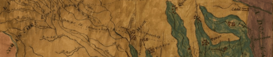
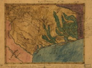
Map of Texas and its surroundings, attributed to Stephen F. Austin, 1822, Library of Congress.

This map, hosted by the Library of Congress (https://lccn.loc.gov/98687158), depicts Texas immediately after Mexico’s independence from the Spanish Empire. The map is attributed to Stephen F. Austin, the first of the empresarios (colonization administrators) whom the young Mexican state allowed to manage and profit from settlement in the tenuously held border region. Austin, cooperating with North Mexico’s existing socio-economic elites and later empresario’s, was hoping to establish a U.S. South-style cotton economy in Texas. This necessitated reshaping diverse local landscapes according top the logics of plantations and commercial agriculture.

The map shows Texas in beige and teal. The latter seems to indicate wooded river-bottoms, the former less timbered prairies, plains, and hill-country. Other Mexican districts are in pink; U.S. Louisiana is in purple. The Sabine River/Rio Sabina can be seen clearly along the U.S.-Mexico border, curving into the teal in the north and emptying into Sabine Lake in the South. Roads cross it twice, leading to Opelousas and Natchitoches out of Texas (and notably not to Pecan Point along the Red River). Austin marks several indigenous communities on the map, one on the Sabine. The spelling is, to me, all but incomprehensible, and the name does not really align with any group inhabiting the region  at the time. But the position indicates that Austin is marking the Nadaco/Anadarko community, part of the larger Caddo political and cultural community that had inhabited the region for millennia. (Perhaps this is meant to indicate Cherokee newcomers who had begun settling in the region, but I doubt it.)  Surrounding communities–Caddo/Cadó, (Hasinai) Texas, Quichies/Kichai, Alavanes/Alabamas (newcomers to the region), etc.–also extracted resources from river valley at that time or in the preceding decades. The Alabama and Cochates/Coushatta had lived on or near the Sabine a decade or so earlier.

The woodlands and unmarked prairies of the Sabine were zones of agriculture and the extraction of resources stewarded and extracted by indigenous communities, sometimes for market use (bear and deer hides, for example) but usually for localized subsistence. The Sabine Valley, not to mention the entirety of Texas and much of West Louisiana, is represented as an indigenous space. Nacogdohces, San Antonio de Bejar/Bexar, and La Bahia are tiny islands of Spanish-speaking settler society in a sea of diverse native cultures. This is a map of, to use Kathleen DuVal’s term, native ground. Simultaneously, this map represents a project to undermine that status through colonization.

EDIT: The incomprehensible labelling likely does not refer to the Nadaco Caddo, but to the Yowani Choctaw, often rendered as Iguanés or something similar in Spanish. These Choctaw had immigrated into the area in the mid-eighteenth century and assimilated into the Caddo cultural and political network. In contrast, later Choctaw immigrants to the region maintained independence, linking to hispanophone communities in the area. Most Yowani relocated into Indian Territory in the nineteenth century. Members of the Mount Tabor Indian Community, a controversial group operating primarily out of modern Rusk County, Texas, claim Iowan descent.

Posted in Document: Image | Tagged | Leave a comment

Introductions & Abstract

Hello, and welcome! I’m Bryson Kisner, a Ph.D. candidate in rice University’s History Department. I primarily study the nineteenth-century U.S. and the U.S. South through the lenses of environmental and borderlands history. I also dabble in longer periodizations and broader geographies, such as the Atlantic World.

My dissertation—“From Borderland to Southern Land: The Changing Landscape of the Sabine River Valley, 1800-1877″—studies how a diverse and dynamic set of (often competing) communities reshaped and utilized the landscape of the Texas-Louisiana border region, while maintaining a focus on how local ecologies abetted or impeded them. For example, the watershed’s environments shaped the region’s historical and present demographics. Though inhabited by diverse communities, much of the watershed was and is sparsely populated. These landscapes also encouraged the river’s reoccurring status as a border between polities. While the importance of the river-border has declined, the valley remains sandwiched between more populous regions that attract greater scholarly attention. As a result, the Sabine Basin itself lies at the edge of more-studied geographies and histories.

I came to this project for several reasons. I have familial roots in Texas (including East Texas) extending into the nineteenth century. I was born and raised in Texas, myself. The construction and contestation of borders are integral to this region’s past and present. Furthermore, it faces local ecological challenges that manifest environmental crises operating at larger scales of time and space. I was aware of these realities from an early age. My maternal grandmother’s family had flip-flopped across the shifting Mexico-U.S. border several times since the 1830s. My paternal grandmother remembered the Dust Bowl. My grandfathers both grew up on Texas farms. I was raised in Central Texas amidst rapid urbanization, suburbanization, and immigration-driven population growth. My professional interest in borders, the environment, and regional history stems from these familial and personal histories. I came to studying the Sabine Basin, in particular, through an established historian’s, Dr. Frank de la Teja’s, comment on the region’s  understudied communities. I quickly became intrigued by these historiographical gaps. My dissertation evolved from there.

This blog has several objectives. First, it makes my project accessible to a larger audience. Sharing my work at conference venues, through academic publications, and in classrooms is a given. But I believe adamantly that academic work should be public-facing and accessible. This website will hopefully help share some of my work with a larger audience. Second, this blog tracks my progress as I work. Third (and theoretically), it allows me to link my dissertation with any side projects that I engage with over the course of my candidacy. Fourth (and finally), it will allow me to simply muse on the things that make doing history interesting.

I hope that that this will be a resource to people looking to learn about the history of the Sabine Basin (West Louisiana, East Texas) and its communities. I also hope it will provide insight into the dissertation process, graduate school, and professional history for those who might be considering this line of work.

Thanks for reading, and I hope you enjoy!

Posted in Uncategorized | Leave a comment

Hello world!

Welcome to Rice University Blogs.

Either start blogging right away or take a few minutes to turn your blog into a normal web site!

Posted in Document: Image, Uncategorized | 1 Comment